The Dearne Valley Green Heart Partnership undertook a Phase 1 Habitat and Species Mapping exercise in September 2011. This has been integrated into the work of the DVLP and this section is extracted from that document.
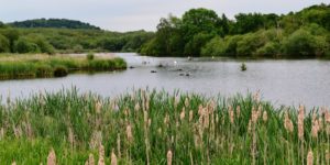
Over the centuries natural habitats have been changed by human intervention. In particular much of the Dearne’s original woodlands have been lost and scrub- grassland habitats cultivated. The Dearne Valley in particular has probably seen the greatest changes from having a natural habitat of a clean-flowing river, with oxbows, willow carr, swamp and grazed seasonal flood meadows to a polluted industrial area and now back to a river of reasonable quality supporting Otter, Eel and Brown Trout. The wider Dearne Valley landscape has historical links with Romans, Anglo- Saxons, Vikings and the Normans and much of the land was cleared of woodland and farmed with many new hamlets and villages emerging. The period of the Second World War saw the biggest change to the landscape with more land being ploughed and the advancement of opencast and deep coal mining in the area. However, small pockets of natural habitat remained and still do to this day. Recently, there have been man-made changes from industrial land back to semi-natural habitats again throughout the Dearne Valley and the associated wildlife has once again become diverse and abundant. Species groups that make the Dearne Valley their home have been recorded and mapped.
The aim of the Phase 1 survey was to gather a record of all semi-natural habitats throughout the Dearne Valley which will then useful to planners and conservationists in determining which sites deserve consideration for protection as SSSI, Local Wildlife Sites and Local Nature Reserves.
As a starting point, Phase 1 Habitat maps were obtained from Natural England. These were from the early 1980s. The period of these 1980s maps presented a much different landscape throughout most of the Dearne Valley to what exists at the present time with a lot of coal mining activity then. There were a number of deep mines and areas of spoil heap which formed much of the central Dearne Valley landscape but a lot of the surrounding rural landscape had changed very little.
To bring the landscape and habitat changes up to date, current Barnsley MBC maps, OS maps, new road systems maps, new industrial buildings and linking re-landscaped areas were put onto a new DVGH Phase 1 Habitat map. A recent Local Wildlife Sites survey also provided additional and up to date information for some key parts of the new DVGH map.
The final update was to visit various parts of the Dearne Valley area and make any changes necessary to the 1980s mapped habitats, including land use.
Over the years since the early 1980s Phase 1 Habitat Survey some new habitats have been created artificially but also there are habitats which have self-recovered since the past industrial period and small areas of original habitat which existed throughout the industrial period of the Dearne Valley. These main Phase 1 Habitats are identified and highlighted in 64 individual map tiles. Rather than replicate the details of all 64 tiles, please refer to the accompanying document.
To complement the Phase 1 Habitat mapping, groups of species were selected to show recent abundance of these within the Dearne Valley.
The following groups of species were highlighted as being the most important within the area: Bats, Butterflies, Herptiles (reptiles and amphibians), Mammals (excluding Bats) and Bird species. These also include Schedule 1 species, UKBAP species and Red List species. To be a meaningful exercise, only records within the area from the past 5 years were selected for the above species groups as some habitats have changed, some species are declining and some new species are occurring.
Plants were not included because there has been a recent survey and a Plant Atlas of South Yorkshire produced which covers in detail each 1 km2 of South Yorkshire.
Barnsley Bird Study Group has recently produced a Breeding Bird Atlas which covers all the Barnsley Recording area and this has overlaps into the other Borough’s so this was a very useful up to date source of invaluable information. There are a remarkable 8 Schedule species and 17 UKBAP and Red List bird species found within the DVGH area.
Many years ago there would have been varied landscape of natural habitats and species of flora and fauna. This changed gradually over the period of history through man’s expansion in this area up to the turmoil of the industrial period. Farming has also had a big part to play in this change from being labour intensive to the modern mechanised period of today.
Over the period of time species have been lost, some have survived and new species have emerged. The causes to the changes to the populations of various species is very complex with no particular item of blame but a whole mixture of landscape and habitat change, a national shift of some populations, perhaps climate change and the introduction of alien species.
Habitats can survive though and regenerate but the biggest changes and those most beneficial to wildlife have been from human intervention through recent re-landscaping of the central Dearne Valley and other post-industrial sites within the area. Remarkably many species have survived and although isolated in some cases they continue to survive and maintain small populations. Other species have taken advantage of the recent landscape changes and habitat creation to increase their populations and other new species have arrived to hopefully start new generations.
There are currently several bat species which occur within the area and of these Noctule Nyctalus noctula, Soprano Pipistrelle Pipisrellus pygmaeus and Brown Long-eared Bat Plecotus auritus are the species most at risk and are UKBAP priority species. As well as the three species most at risk other bat species have declined within the area in the past but now there are many new created habitats which support insect life for bats to feed on.
UKBAP mammals other than bats that occur in the area are Brown Hare Lepus europaeus, Harvest Mouse Micromys minutus, Otter Lutra lutra, Water Vole Arvicola terrestris and Western European Hedgehog Erinaceus europaeus. These species need more survey work and in particular Harvest Mouse to see if there are other habitats that hold small populations of this fragile species. Otters need safe holts in quiet habitats for them to become established and Water Voles require additional off-river ponds creating as a habitat which Mink may not visit.
The UKBAP butterflies, Dingy Skipper Erynnis tages, White-letter Hairstreak Satyrium w-album, Wall Lasiommata megera and Small Heath Coenonympha pamphilus require habitats maintaining and new habitats creating for survival and expansion. UKBAP Herptiles were probably once more abundant but have now become rather rare, local or in some areas non-existent but Grass Snake Natrix natrix, Great Crested Newt Triturus cristatus, Adder Vipera berus and Common Lizard Zootoca vivipara are the four species from the five which require habitat management and creation to save them from further decline and regional extinction. There are about 95 breeding bird species that occur in the area with some species quite scarce and isolated but others abundant and expanding. Within the area much of the work of the RSPB and the Garganey Trust is focused on maintaining and expanding populations of these bird species which are threatened within the UK and at the same time indirectly helping other species.
Locations in the Dearne
All locations that are related to this content are as follows:
-
Denaby Ings Local Nature Reserve
A Local Nature Reserve owned and Managed by Yorkshire Wildlife Trust.
-

New Park Springs
New Park Springs is a site comprised of wetlands, grassland and woodlands located in Grimethorpe, South Yorkshire.
-

Phoenix Park
Phoenix Park is an area of community woodland area nestled between the towns of Goldthorpe and Thurnscoe in South Yorkshire.
-

Worsbrough Mill and Reservoir
Worsbrough Mill is a working 17th century water mill located in a 240 acre Country Park in Worsbrough, South Yorkshire.
-

RSPB Old Moor
The Old Moor is a nature reserve maintained and operated by the RSPB located in the heart of the Dearne Valley, South Yorkshire.
-

Wombwell Wood, Wombwell
Wombwell Wood is an ancient semi-natural broadleaf woodland located in the Wobwell, South Yorkshire.